Simple, powerful platform
Automate geospatial insight generation with advanced AI
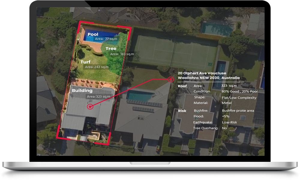


Highly detailed and current, surveying-grade accuracy, change insight in user-defined time intervals, comprehensive and most frequent urban coverage in Australia.
Interactive and user-friendly web app, batch processing tools, API integration, automated and detailed reporting in various formats.
Usage-based pricing models designed for businesses of every size.

Automated cloud-based processing workflow, rapid turn-around, integrated training data collection platform, user feedback for continuous AI improvement.

Use our near-inspection quality property analytics to achieve one-click quote generation, estimate accurate housing premiums, improve customer experience and get notified of property changes used for automated renewal process.

With our analytics platforms, you can get an objective reality check of properties, check history of changes occurred to every property, track urban growth that affects property value and identify high-growth suburbs.

Know the property’s conditions such as roof quality, built material, solar panels and pools and offer services based on each customer’s needs. Use our data to conduct an effective marketing for every suburb in Australia.
Have you got a new use case?
Leverage our expertise to help your organisation create custom workflows & analytics.
Contact US
Mapizy team awarded by Deloitte for solving two technology challenges for insurance industry. We participated in the Gravity challenge supported by a number of leading organisations like AWS and AIRBUS and were the only company awarded twice among 42 other teams across Australia.

Mapizy agriculture AI solution was awarded first place in Maxar Hackathon. Our solution uses Maxar images and creates detail forest inventory. This is a great opportunity for Mapizy to advance its popular forest inventory solution.
Maxar Blog »
Mapizy was accepted into the competitive ON Prime, the national sci-tech pre-accelerator powered by CSIRO! The 8-week program allowed our team to work with some incredible industry leaders to take our presearch from idea to impact.
Mapizy was awarded the highly competitive Business Research and Innovation Initiative (BRII) grant, working on a project to count fish using advanced AI technologies. The team worked with leading marine biologists from the Australian Institute of Marine Science (AIMS) to solve one of the difficult challenges in marine biology, which is currently done manually.

We are excited to know that Mapizy has been awarded Access Asia grant by WA Department of Job, Tourism, Science and Innovation to present and exhibit at GeoConnect Asia 2021 in Singapore. We have developed an AI solution for mine rehab through satellite images. Our solution is less costly and more frequent.
Mapizy was chosen to be part of Singapore Landing Pad Supported by Australian Government, Austrade. The Landing Pads program provides market-ready startups and scaleups with potential for rapid growth as a cost effective option to land and expand into major global innovation hubs around the world.

Director of BD, MAXARKevin Bullock
“Mapizy was one of participant companies in MAXAR hackathon and their unique AI solution for forest inventory generation from MAXAR satellite images awarded first place. All judges were impressed by the quality of Mapizy submission in both industry needs analysis and AI technology.”

Vice President, Toyota’s Woven PlanetMandali Khalesi
“Mapizy team was engaged by us to develop HD mapping technologies. We believe Mapizy has provided our team with georeferencing technologies that allow for more accurate localisation of objects in images.”


